


PORTO COVO
PORTO COVO
The village of Porto Covo as we know it today is not the result of organic growth, but rather a planned creation from the late 18th century.
Its modern history is intrinsically linked to the vision of a single key figure: its founder.

Jacinto Fernandes Bandeira: The Visionary and His Rational Project
Jacinto Fernandes Bandeira was a powerful and wealthy merchant in Lisbon. His fortune largely came from maritime trade and specialization in the timber business for shipbuilding.
His connection to Porto Covo was a purely strategic and logistical act:
– Jacinto Fernandes Bandeira was an influential merchant of naval timber in Lisbon. The Porto Covo estate was attractive due to the abundance of cork oaks nearby, one of the dense woods used to build the framing of ships.
The property had a seaport which, although small in scale, was essential for the export of regional goods, especially fuels.
The Enlightenment Foundation (1794)
This foundation was an act of “Enlightenment applied to economics”. The goal was clear: to create a village that would bring “great utility to the trade and transport of the Alentejo province”. Its planned central square and orthogonal grid are a model of Enlightenment Urbanism, where reason and order prevailed over spontaneous growth.
The purchase of the estate around 1792 was the territorial basis for a rational development project. In 1794, just two years later, Bandeira had already “begun a settlement”.
His success and initiative earned him the recognition of the Portuguese Crown. In 1796, he was granted the title of Lord of Porto Covo by Royal Charter, becoming the foundational core of the Viscounty and, later, the Earldom.
From Cargo Port to Tourist Resort
From the 19th and 20th centuries onward, the town’s purpose shifted. Born for trade, Porto Covo transformed into a tourist resort, taking advantage of its planning and natural beauty.
This phenomenon defines its current identity. The difference between the resident population (1,091 inhabitants in the 2021 Census) and the summer population is dramatic. During the peak season, the number of people can multiply by a factor of 10 to 15, making it one of the gems of the Vicentina Coast.
Pessegueiro Island: The Historical Heart
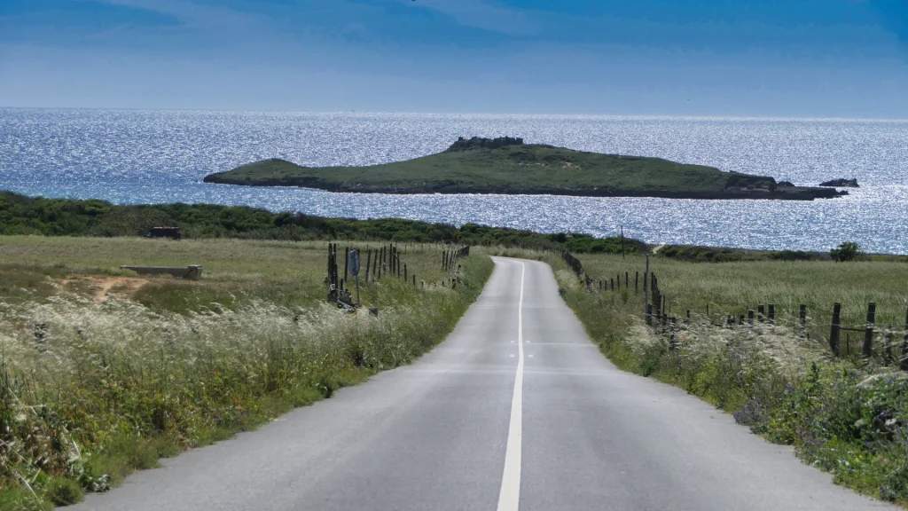
The history of Pessegueiro dates back to the dawn of humanity, but its first major historical significance lies in its value as a natural harbor, spanning more than two millennia. The island, which today lies just 250 meters off the coast, is actually an “emerged fragment of a massive fossil dune”. We inherited its name from Roman Antiquity: Pessegueiro derives directly from the Latin “piscarium” or “piscarius”, which means fishery or fishing spot.
The Roman Root: The Piscarium
During Roman Antiquity, Pessegueiro Island and the adjacent channel functioned as a crucial ocean port.
– Activities were based on the export of ores and a thriving fish processing industry, namely salting, which began in the second half of the 2nd century AD.
– This maritime trading post was essential for regional trade. Archaeologists have documented ancient port facilities dating back to the Iron Age and, later, the Roman Era.
The Time of the Forts: The Destroyed Sentinel
In the 16th and 17th centuries (namely during the Iberian Union, under the Philip Kings), the Alentejo coast was subject to major fortification projects to protect natural harbors from piracy and enemies of the Crown.
It was in this context that the Pessegueiro Fort complex was built, a dual defense system. The Island Fort was the main bastion, while the Redoubt on the mainland (the auxiliary bastion) had the specific mission of defending the sandbar and the access channel.
This fortification project was abandoned in 1603 and completed in 1690, during the reign of King Pedro II.
The Legacy of the 1755 Earthquake
The final fate of this military complex was not sealed by a human enemy, but by geological force. The violence of the 1755 Earthquake devastated the coastal constructions.
The distinguished Enlightenment intellectual, Dom Frei Manuel do Cenáculo Villas Boas, traveled along this coast in 1794. In his diary, he recorded his visit to the fort, describing it as “very regular”, but already “destroyed by the earthquake”
The mainland Redoubt, part of the same system, shared this lesson in fragility. The island remained a testament to the destruction when Porto Covo was given new life through Jacinto Fernandes Bandeira’s civil and Enlightenment project.
The Rota Vicentina: History on the Wild Coast
Porto Covo is the ideal starting point to explore one of the most well-preserved stretches of coastline in Europe. This town lies right on the Rota Vicentina, an extensive network of walking trails totaling around 750 km.
The Fishermen’s Trail
It follows the sea closely at all times, along the paths used by the locals. It is a narrow trail that can only be done on foot, along imposing cliffs, with a lot of sand. A challenge offering constant contact with the sea breeze, the harshness of the coastal landscape, and the presence of wild nature.
– This trail follows the sea access paths used by local fishermen.
– It is a strictly pedestrian trail, not accessible by bicycle due to the nature of the terrain.
– A large part of the Rota Vicentina (the Historical Way) is internationally recognized, holding the “Leading Quality Trails – Best of Europe” certification.

Southwest Alentejo and Costa Vicentina Natural Park (PNSACV)
Official Extent and Characterization.
The Park stretches along a narrow, vital coastal strip, covering territories across four municipalities (Sines, Odemira, Aljezur, and Vila do Bispo).
Geographical Limits: It extends from São Torpes (south of Sines) to Burgau (on the southern Algarve coast).
Total Area: The Park covers 89,568.77 hectares, with a significant marine component of 28,991.52 hectares. The protected marine belt extends 2 km in width.
Objective: It was designated to preserve its high diversity of coastal habitats, focusing on the richness of flora (due to the presence of several endemic species) and fauna (where birdlife and fish species play a prominent role).
Geology and Unique Biodiversity
The PNSACV is a mosaic of landscapes serving as a refuge for rare and endemic species.
Symbol of the Park: The sea cliffs. These steep, jagged cliffs hiding small sandy beaches were chosen as the symbol for their strength and variety.
The Unique White Stork Phenomenon: The Park is the only place in the world where the White Stork (Ciconia ciconia) builds its nests on coastal rocks and sea cliffs, instead of trees or rooftops.
The Marine Otter: The Park shelters the only known marine population of otters (Lutra lutra) in Portugal, which uses the marine environment for fishing.
Richness of Flora: Around 750 flora species have been identified in the Park. Of these, more than 100 are endemic, rare, or localized, and 12 do not exist anywhere else in the world. Examples include Biscutella vicentina and Cistus palhinhae.


 Carnaxide – Sines / Portugal
 +351 918 232 292
 geral@hiketime.pt


